- First, pack up your vehicle with clothes, extras, snacks, water, and if small kids, a portable toilet with extra bags.
- Second, gas up vehicle
- Third, bring your map/GPS/laptop, whatever devices you have
First- you need MapQuest directions...
mine are:
5. Merge onto I-10 E toward INDIO. (go 64.6 miles)So, here we are on I-10 E
6. Take the DESERT CENTER RICE ROAD/CA-177 exit, EXIT 192. (go 0.2 miles)
7. Turn LEFT onto CA-177/DESERT CENTER RICE RD. Continue to follow DESERT CENTER RICE RD. (go 40.3 miles)
8. DESERT CENTER RICE RD becomes CA-62/AQUEDUCT RD. (go 27.4 miles)
9. Turn LEFT onto US-95. (go 47.7 miles)
10. Merge onto I-40 W/US-95 N via the ramp on the LEFT. (go 10.7 miles)
11. Merge onto US-95 N toward SEARCHLIGHT/LAS VEGAS (Crossing into NEVADA). (go 79.7 miles)
12. Merge onto US-93 N/US-95 N via the exit on the LEFT toward HENDERSON/LAS VEGAS. (go 21.9 miles)
13. Take the LAS VEGAS BLVD exit, EXIT 75, toward DOWNTOWN LV. (go 0.3 miles)
14. Turn RIGHT onto N LAS VEGAS BLVD/NV-604. (go 0.1 miles)
15. Turn RIGHT onto E BONANZA RD. (go 0.0 miles)
16. End at Las Vegas, NV
---------------------------------
Approx. 4 hours and 43 minutes-
(click to enlarge if you can't see)
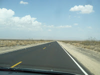
Here you notice how bumpy and old the road feels for the next 64.6 miles
 Here is another view out the passenger side window, in case you couldn't see well enough out the front windshield
Okay, next leg of trip...this is where we are on the map
 (Gasp!) Oh look at how beautiful the road is! It is soooooooooo smooth! Good thing because we have 40.3 miles on this beauty!
 Oh L-O-O-K!!!! A car! Hurry and wave to them!!! "HI!!!!!"
 Here is the surrounding countryside...all along here are train tracks, and a berm...somehow, some time, people come out here, collect the surrounding rocks and with those rocks, create messages and initials. I'm not sure what this means, but someone took a long time to make it!
 There used to be a "Shoe Tree" out in the middle of nowhere. Someone burned it down and now people have started a "Shoe Fence"...don't know why, don't know how...but it sure breaks up the monotony.
(Click to enlarge)
 Ahhhh...finally at Vidal Junction! (27.4 more miles until US 95!)
At this literal crossroads is this country store/gas station on one side, and...

 The California Agricultural Inspection Station across the street.
Oh yeah, there used to be an old antique outdoor flea market on the opposite corner....
 But as you can see...it is now empty.
 I see rain clouds ahead. This can be very dangerous as this road has many whoop-de-doos in it that can flash flood very quickly.
The rain does smell good though!
 This is when you start saying, "When in the *@&^ are we going to get there?!"
 I begged for a potty break and something to drink....when I saw these 2 sad houses...I sure hope no one is living in them!
(you gotta see these! Click on photo)
 FINALLY we are US 95!
We will be on this for over 79.9 miles! (Ugh!)
 This mean we are almost there! Yippee!
Just around the corner and......

It might be hard to tell, but this is on top of US 95 overlooking Clark County
 Downtown Las Vegas, near Fremont Street
We have arrived!
(That was the longest 5 hours in my life!)


3 comments:
Thanks to the blog owner. What a blog! nice idea.
It enables us to express our feelings and opinions.
What a ride! And seriously, bags for an on the road potty? Fur real? As weird as this sounds, I would love that trip! Think I did it once but ours had us taking a "back road" (bicycle track) through the country in the night. Totally. Black. Eerie. Las Vegas was a little eerie for me, too, for that matter. BUt have fun...don't mind me...
Post a Comment